According to Ermanno Armao, Località, chiese, fiumi, monti e toponimi varii di un’antica carta dell’Albania Settentrionale (Localities, churches, rivers, mountains and various toponyms from an old map of Northern Albania), Rome, 1933.
“Every village name, every ruined church, every broken bridge tells an ancient story worth hearing.”
Researcher, orientalist, librarian, cartographer and expert on Albanian culture, Ermanno Armao (1887–1960) devoted himself with passion and scientific rigor to documenting the territory of Northern Albania. He entered the Italian consular career in 1912 and held posts in Antalya, Córdoba, Shkodër, Boston, Istanbul and Cologne until 1940.
His cartographic and toponymic contribution to the city of Shkodër, the historic seat of Italian diplomatic missions, is particularly important. Inspired by the work of the Venetian cartographer Vincenzo Coronelli, Armao thoroughly analyzed the map entitled Corso delli fiumi Drino e Boiana (Venice, 1688). The result of this study is the work entitled Località, chiese, fiumi, monti e toponimi varii di un’antica carta dell’Albania Settentrionale (Localities, churches, rivers, mountains and various toponyms from an ancient map of Northern Albania), published in Rome in 1933 and later translated into Albanian.
In this work, Armao compares the data from the 17th-century map with contemporary reality, noting with astonishment the accuracy of much of the information, which testifies to the reliability of historical sources and the stability of certain place names over the centuries. This approach illustrates both serious scientific work and a genuine desire to know and explore the country. Two Venetians, Armao and Coronelli, as a reminder of the historical ties between Shkodër and Venice.
Armao’s book begins with a description of the moment he discovered the existence of Coronelli’s maps and information. After outlining his previous research on Albanian territories, Armao presents his own approach. He begins by verifying the information from Coronelli’s maps, emphasizing the ease with which he confirmed them, as most of the territories described retained the same characteristics.
Armao’s approach was not solely theoretical: as mentioned, he traveled the region on foot to visually confirm the localities, churches, mountains, and rivers cited by Coronelli, correcting any inaccuracies. He also paid particular attention to the transcription and phonetics of Albanian names, carefully analyzing phonemic peculiarities such as /q/, /ç/, /gj/, and /xh/, and illustrating their Italianized variants (e.g., Shirqi → Sirichio; Gjadri → Giadri).
His study can be considered a symbolic census: alongside the names of villages, Armao inserts religious symbols (cross or crescent) to indicate the dominant faith, thus outlining a social reading of the territory. The list of churches, families, and geographical features provides a complete picture of Northern Albania at the time.
Armao presents his work with the conviction that to know a people, its inhabitants and its history, one must always refer to geographical maps and that only systematic research allows one to orient oneself in the flood of available information. While showing modesty, the author hopes, on the one hand, that his book will be well received by readers and researchers, both Albanian and foreign; on the other, he expresses the satisfaction he has derived from the rediscovery of an old map, from his research and from a better knowledge of the Albanian land.
Armao’s publication should be understood as a testament to his desire to know and understand the territory in which he lived. Through his writings, foreigners, Italian and non-Italians alike, came into direct contact with nature and, at the same time, discovered its potential. In this sense, cultural exchange and field research appear to be the most relevant means for learning to know and appreciate one another.
Based on Armao’s work, several itineraries can be imagined for foreigners and Albanians alike who wish to explore our country and discover its history and nature.
The route we propose is that of the prehistoric and medieval fortifications located on the left bank of the Buna River.
Itinerary: Prehistoric and medieval fortifications
- Prehistoric fortification of Beltoja (Baltogna)
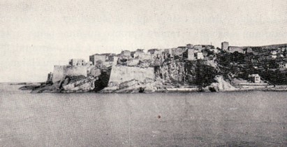
 The Illyrian fortified settlement of Beltojë, located south of Shkodër, also known as “Qyteza e Beltojës” (“Beltojë City”), is an important testimony to the defensive architecture and territorial organization of the Illyrian tribes, particularly the Labeates. It is located on a rocky hill rising to an altitude of 168 meters, in a strategic position overlooking the surrounding plain and the natural routes connecting the interior of the country to the Adriatic coast.
“…which overlooks the plain of Drinas and Trush…” (Armao, 1933:41)
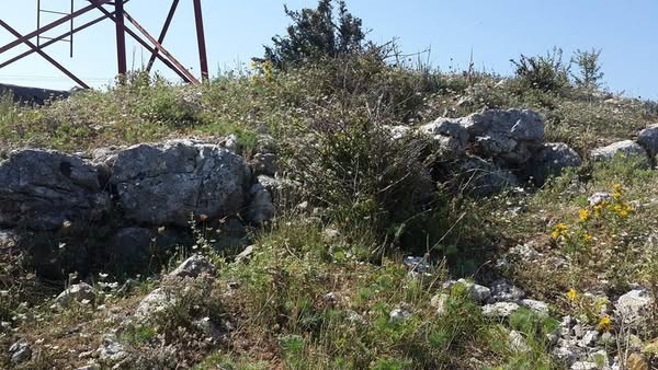
Various studies describe the site’s morphology, fortification type, and excavated materials, highlighting that Beltojë was part of a coordinated system of fortified settlements, alongside other sites such as Ganjollë and Gajtan. Topographical surveys, field research, and comparative analyses have established that the site dates back to the Iron Age and was continuously occupied during the Classical and Hellenistic periods. While its defensive function is evident, its economic and symbolic role has also been highlighted. This body of research thus contributes to a better understanding of proto-Albanian urbanization in northern Albania and fuels the debate on the Illyrian settlement network in the Balkan context.
The site is located 25 kilometers from Shkodër and today you can still admire:
- segments of walls and towers, along which the solidity of the medieval defensive structure is revealed;
- the surrounding rural landscape, which invites reflection on the relationship between man, defense and the environment;
- a spectacular view of the Buna Gorge, the valley and the sea on the horizon.All these elements provide an ideal setting for a photographic spot with impressive views, far from the crowds of the more frequented fortified sites.
Practical advice: don’t forget your binoculars to better observe the morphology of the gorges and navigation on the river.
Medieval Fortification of Belaj (Belagni)
 “…The Buna cuts its course through the hills, forming what is called the “Belaj Strait”, barely 1000 meters wide, where it is possible to cross the river on foot and where, in 1477, a naval battle took place between the Venetians and the Turks” (Armao, 1933: 43)
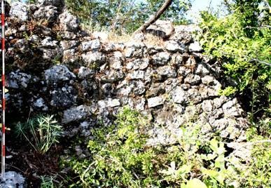
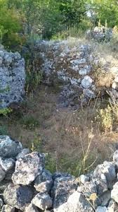
Belaj’s strategic location in the eponymous strait connecting the Belaj and Fraskanjel Heights has made it an important checkpoint for river traffic since ancient times. Venetian, Turkish, and Albanian sources attest to the existence of a fortification, probably dating from the Balshaj period (late 14th century), which played a key role during the two sieges of Shkodër in 1474 and 1478-79. Various sources, including the accounts of chroniclers such as Gjergj Merula, confirm that the fortification was conquered by the Turks in 1474 and then reinforced and maintained over the following decades, with the aim of controlling the Buna River and preventing the arrival of Venetian reinforcements towards the city.
The ruins of the fortification—a rectangular perimeter of approximately 40 x 30 meters with two towers, one circular, the other square—display typical features of medieval masonry. The article concludes by suggesting that further systematic archaeological excavations could shed light on the structure’s exact origins and stages of development.
The site is located 15 kilometers from Beltojë, and today one can still admire:
- well-preserved remains of walls of remarkable dimensions;
- the two clearly identifiable towers on the east and north sides;
- a breathtaking panorama: opening onto the Buna Gorge, the Shkodër Plain and the Adriatic Sea; • a suggestive natural environment: a river corridor where history and nature meet.
This place is worth visiting not only for the immersive experience it offers in the heart of nature, allowing you to walk between ancient walls offering a panorama of the gorges that reveal the strategic function of the site, but also for the connection it creates with history, telling the struggles of the local lordships, the Venetian rivalries and the Ottoman wars. Note: Perfect for a short excursion, ideal for lovers of hiking and history in the field.
Prehistoric Fortification, Mali i Gjymtit, Pentar (Penetari)
 “…Even Penetari, located on the left bank of the Buna, near Belaj, has existed for 500 years.” (Armao, 1933: 99)
Mount Gjymti (Mali i Gjymtit), located in the low plain of Shkodër (NënShkodër), is a hill dominating the left bank of the Buna River, precisely where it, crossing a tectonic fault, forms the impressive Belaj Gorge (Gryka e Belajve). This natural passage, of tectonic and erosive origin, is framed by two mountainous reliefs: Mount Belaj to the south (Albanian side) and Fraskanjel to the north (currently in Montenegrin territory).
At the summit of Mount Belaj, at an altitude of 118 meters, lies a natural terrace called “Tabja e Belajve,” offering a vast panoramic view of the entire Shkodër plain, from the urban center to Velipojë and the Adriatic coast. This strategic position favored the construction of a medieval fortification, of which important remains remain today: rectilinear walls, two corner towers (one circular, the other square), as well as fragments of walls made of limestone bound with mortar.
According to historical sources and local legends, these hills housed two castles in the Middle Ages, named Bela and Fraska, symbolically attributed to two Albanian princesses who supposedly ruled the region and imposed taxes on the navigators of the Buna. These castles were probably destroyed or redeveloped under Venetian rule, then conquered by the Ottomans in 1474 during the Siege of Shkodër. It was then that the site was reinforced as a strategic blocking point to prevent Venetian troops from accessing the river.
The region is ideal for hiking enthusiasts and offers:
- well-preserved remains of medieval walls, especially on the north and north-east sides; • the discovery of remains of defensive towers integrated into the fortified structure; • a panoramic view of the Buna Valley, the city of Shkodër, the homonymous lake and the Adriatic coast; • a natural environment rich in biodiversity, where history and landscape blend harmoniously.
Practical advice: Wear sturdy hiking shoes, as the natural terrain can be slippery at