Kurt Hassert (1868–1947), a German geographer and cartographer known for his explorations in the Arctic, Africa, and the Balkans, undertook an important journey to northern Albania in the summer of 1897.
Albania attracted his attention because of its wild landscapes, its unique geological structure and its traditional mountain society.
His starting point was Shkodër, from where he organized nine excursions through the mountains, valleys and towns of northern Albania and Kosovo.
Hassert is a traveler who combines the observation of nature with the description of local culture, although his interest lies more in natural and geographical elements, while adopting a narrative style easily reusable in contemporary tourist guides.
For Hassert, Upper Albania represented one of the most isolated regions of Ottoman Europe at the time. He noted the lack of coastal lines penetrating deep inland, making travel particularly difficult. To reach this remote mountainous area, the traveler had to cross several mountain ranges, often crossing two or more passes in a single day.
Hassert describes this complex network of mountains as part of the Dinaric Alps,[1]according to the geographical terminology of his time, which also included Bjeshkët e Nemuna, today known as the Albanian Alps.
With their particular geomorphological identity, the Dinaric Alps appear as a complex tangle of valleys, deep gorges and high peaks, where each strenuous ascent is followed by equally grueling descents through scrub-covered slopes.
For Hassert, this territory was a place where nature and man put the traveler to the test, both physically and mentally. Therefore, after obtaining the necessary permits and official support, he and his team chose Shkodër as their starting point. They organized their expedition into nine separate excursions, some short, others longer, to better cope with the challenges posed by the Albanian mountainous terrain.
We have chosen to present one of these routes.
The route to Mount Cukal (June 15–17, 1897)
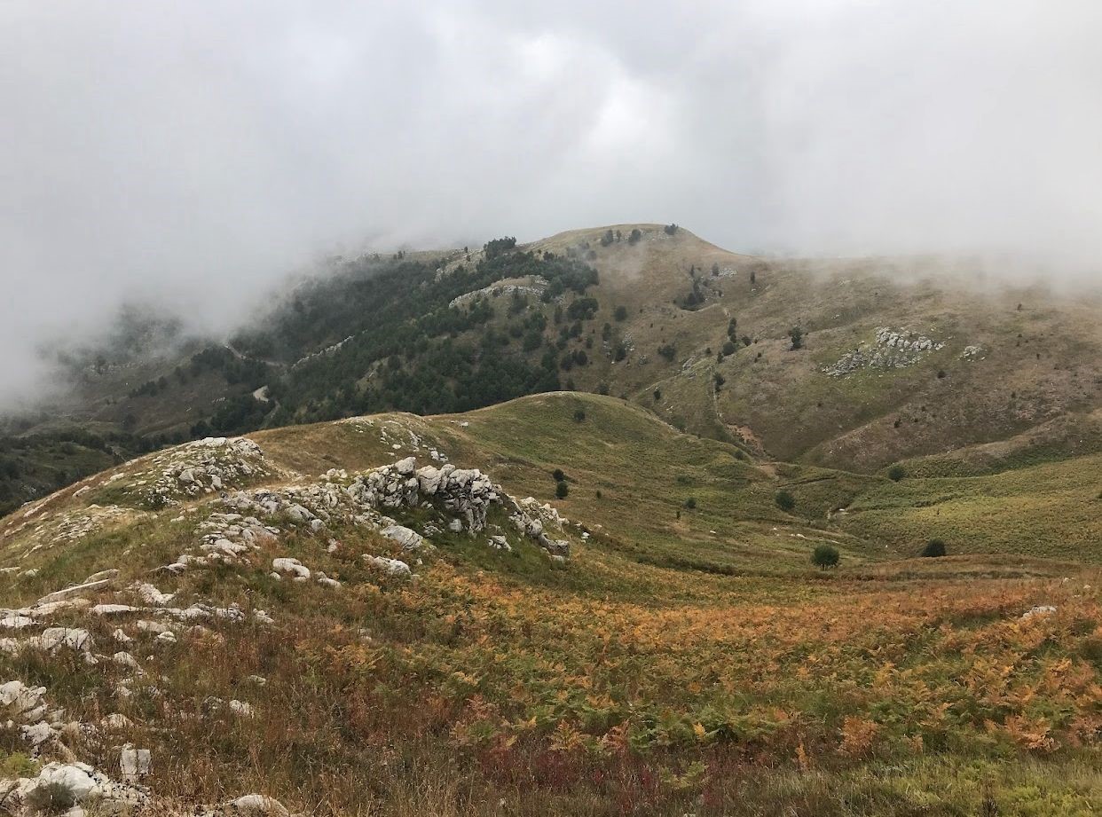
The exploration of Mount Cukal was one of the most extensive expeditions conducted by Kurt Hassert in the Shkodër region. The group set out from the city on June 15, crossing fields covered in ferns and following one of the side valleys of the Kir River, where colorful rock formations were observed. The surrounding forests appeared dense, composed of chestnut and oak trees in the lower areas, and alders on the higher ground.After a harrowing passage along the narrow ridge of Mount Cukal, the group descended into a deep, still-snowy valley, where they set up camp in a remote location. Due to the possible presence of bears and wolves, the night was spent in constant vigilance. The next morning, despite the low temperatures, they began a strenuous climb that took them first to the summit of Mylesifë Peak (Maja e Mylesifës), offering a breathtaking panorama of the Albanian Alps and the southern massifs. They then continued to the highest point of Mount Çukali (1,841 m), where they could fully experience the grandeur and majesty of the Albanian wilderness. After spending the night in the village of Vukaj, the group returned to Shkodër on the third day, following the same route.
Mylesifë Peak (Maja e Mylesifës)
 The toponym Mylesifë Peak (Maja e Mylesifës), used by Kurt Hassert, does not appear on contemporary official maps or in local toponymic sources relating to the Cukal massif region. It is plausible that it is a short-lived local name, a phonetic distortion resulting from the perception of the German author, or a variant designating one of the peaks or slopes of this massif. This is why, in the text, this toponym is presented as coming from the traveler’s memory rather than as an officially recognized geographical designation. Comparison of this description with contemporary maps, as well as with mountain routes currently used by mountaineers and researchers, indicates that this passage probably corresponds to the pass today known as the Muleqith Pass (Qafa e Muleqithit). This correspondence bears witness to the natural evolution of local toponymy, where phonetic variations, combined with the absence of lasting historical standardization, have led to the parallel use of two forms probably designating the same passage.
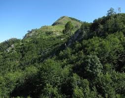
Cukal Peak (Maja e Cukalit)
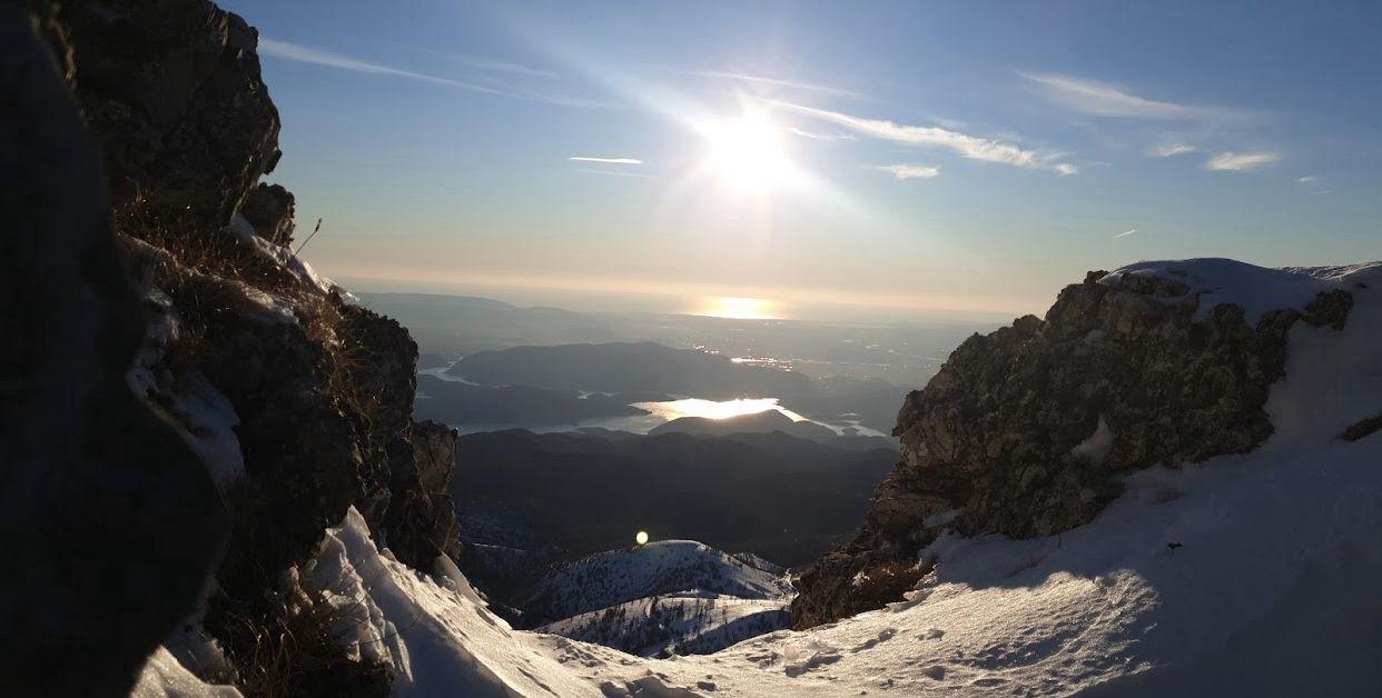 Cukal Peak is the highest point of Mount Cukal, a massif located north of the city of Shkodër, on the border between the historical region of Postribë and the Kir River plain. It stands on a geographical axis between the Kir Valley to the east and the villages of Postribë to the west and southwest. This peak rises to 1,841 meters above sea level (according to Albanian topographic maps and international geographical sources), making it one of the highest points in northwestern Albania, outside the Albanian Alps (Bjeshkët e Namuna) system, and a strategic observation point. It is part of a long and well-defined ridge, whose slopes drop steeply towards the Kir Valley to the east, and more gently towards Postribë. The landscape is characterized by dense forests on the lower slopes (oaks, chestnuts, beeches), rocky and bare slopes on the higher ground, as well as alpine pastures above the tree line. From the summit, the panorama is spectacular: to the north and northeast: the Albanian Alps, including the Jezerca Peak (Maja e Jezercës) and the Iron Peak (Maja e Hekurave); to the south: the city of Shkodër, its plain, Lake Shkodër and the course of the Buna River; to the west: the Postribë hills and, further away, the Lezhë plain; to the east: the Kir valley, then the Pukë mountains. For Hassert, this summit constituted a geographical and emotional point of view, from which the complex relief of inland Albania could be better understood.
The village of Vukaj
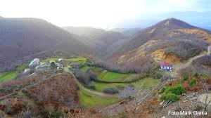 The village of Vukaj is located about 25–30 km north of the city of Shkodër, in the upper reaches of the Kir River. In some ethnographic sources and old descriptions, Vukaj is mentioned as part of the traditional region of Postribë. However, according to the current administrative division, it falls under the administrative unit of Shllak (municipality of Vau i Dejës). This dual attachment illustrates the gaps between the old traditional regional boundaries and the current administrative division. Thus, in historical documents or the accounts of travelers such as Kurt Hassert, who visited the region in the late 19th century, Vukaj is frequently mentioned as part of Upper Postribë, while today it officially falls within the Shllak region. Nestled on the southwest slopes of Mount Cukal, the village is located in a relief characteristic of the transition zones between hills and mountains..When Kurt Hassert passed through in 1897, the region was still landlocked: only a few paths allowed residents and travelers to travel on foot or by animal. Today, the village benefits from a network of rural roads connecting it to both Postribë and the city of Shkodër. This old village is mentioned in Ottoman records, and later in Albanian administrative documents. In the late 19th and early 20th centuries, it belonged to a territory organized according to a clan structure, reporting to the bajrak of Postribë. It has also appeared on the itineraries of many travelers and ethnographers, both Albanian and foreign.
According to various demographic sources, the population of Vukaj declined significantly due to emigration. For travelers of the time, villages like Vukaj played an essential role as stopping places: they offered accommodation, traditional dishes, and a certain sense of security after long treks through alpine terrain. The village is surrounded by a remarkable natural landscape: chestnut and oak forests in the lower areas, summer pastures in the higher areas, as well as nearby caves and water springs, well-known for their local use. Vukaj has long preserved vivid features of oral culture: epic songs, local legends connected with the nearby mountains (especially Mount Cukal and its caves). Until the mid-20th century, the Kanun, a code of customary law, remained deeply rooted here.
In Hassert’s footsteps: how can we relive this journey today?
The route undertaken by Kurt Hassert in June 1897, towards Mount Cukal and the peak of Mylsifë (Maja e Mylesifës), remains to this day one of the most beautiful and demanding routes one can experience in the northern surroundings of Shkodër. Although the landscape has evolved in some respects, the wild nature of the region, with its steep ridges and deep valleys, retains the unspoiled atmosphere that Hassert so enthusiastically described.
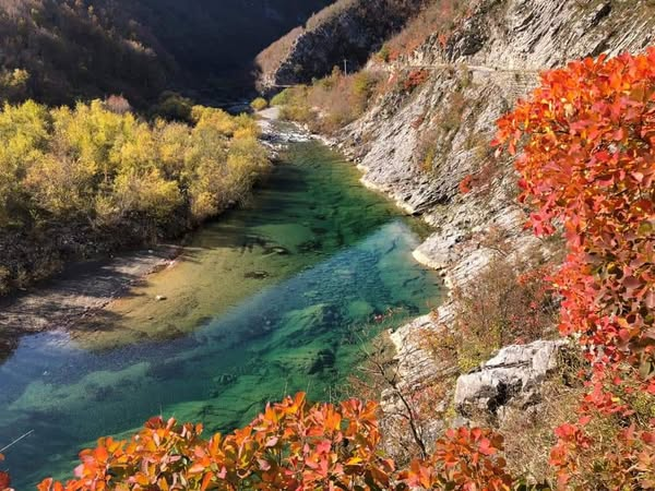
Such a journey would begin today, as it did then, from the city of Shkodër. Thanks to modern roads, one can quickly reach the Kir River Valley by car—one of the most beautiful in Northern Albania. Its colorful rocks and the crystal-clear course of the river offer a spectacular entrance to this mountain world.
From there, the old caravan trail, now used by shepherds and mountaineers, leads slowly up the slopes of Mount Cukal. Dense forests of oak, chestnut, and then beech trees accompany the ascent, just as Hassert had observed them. After a few hours of walking, above the tree line, one of the most remarkable points of the route appears: what Hassert called the Mylesifë Peak (Maja e Mylesifës) (today Muleqith Pass (Qafa e Muleqithit). From this summit, the view opens to infinity: opposite, the Albanian Alps rise majestically, while to the south stretch the plain of Shkodër and, on a clear day, the coast of Buna. If Hassert and his companions had pitched their camp in a valley still covered in snow, today this same place would offer nature lovers a rare experience: a night bivouac under the stars of the Albanian mountains.
On the second day, visitors would reach Cukal Peak (Maja e Cukalit), the highest point of the massif (1,841 m), from where the panoramas are even more magnificent. Access remains relatively isolated: transport in a 4×4 vehicle to the base villages (Plan, Prekal, Vukaj) is required, followed by a 3 to 5 hour walk depending on the chosen route. The ascent is suitable for experienced climbers or groups accompanied by a guide.
Cukal Peak (Maja e Cukalit) offers opportunities for alpine hiking, panoramic viewing, nature observation, and camping. It can be included in combined itineraries with: the Kir Valley, the villages of Postribë, and the supposed Mylesifë Peak (Maja e Mylesifës).
After a stop at the summit, the route descends to the village of Vukaj, a small mountain hamlet where an overnight stay offers a close-up look at traditional Postribë life. The hospitality of the families, the stories of the locals, and the simple yet delicious cuisine create a vibrant connection with the spirit of the place.
The journey ends the next day with a leisurely return to Shkodër, on paths now familiar to the visitor who, following in the footsteps of a 19th-century traveler, will have tasted, if only for a few days, the beauty of this “high and wild” Albania, one of the best-preserved treasures of the Balkans.
[1]In his text, Kurt Hassert uses the term Dinaric Alps / Dinarische Alpen to refer to the mountain range that extends across a large part of the interior of Northern Albania and surrounding regions. This was a geographical convention commonly adopted in Central and Western Europe at the end of the 19th century. At that time, many German and Austrian geographers considered it natural to extend the term “Dinaric Alps” (from the Julian Alps in the north, through Montenegro and Bosnia, to the Albanian Alps). Nowadays, a more precise distinction is made: the Dinaric Alps primarily refer to the mountain ranges that cross Slovenia, Croatia, Bosnia and Herzegovina, Montenegro, and extend as far as northern Albania.
The Albanian Alps (or Bjeshkët e Nemuna) are considered a subset of the Dinaric Alps, but with a distinct geomorphological identity.